Quantcast
Channel: The Lost Fort
Viewing all 241 articles
Browse latest View live

Gnisvärd Ship Setting / Gotland

$
0
0

How about some sunny pics in this grey February? I swear the sun's off vacationing somewhere else in the galaxy, having some drinks in the Milky Way Bar or whatever. But at least she sent a comet mail.

So here are some photos from a ship setting on Gotland, taken on a sunny if cold May afternoon.

Bronze Age ship setting at Gnisvärd, Gotland

Ship settings are stone settings in the shape of a boat that mark grave or cremation burials. They are mostly found in the part of Scandinavia that borders the Baltic Sea (Denmark, southern Sweden, Gotland) though some have also been found in the Baltic States, Finland, Russia and Germany. Their size varies from a hundred metres (the remains of the setting at Jellinge is the largest, it may have been 300 m, though other large ones are usually under 100 m) to just a few metres.

View from the side

The larger settings date to the late Bronze and early Iron Age, while the smaller ones are from the Viking time (ca. AD 800-1150*). Ship settings should not be confused with boat burials of the Vendel time (AD 550-800, the best example is Haithabu / Hedeby) and the Viking time (fe. the famous Gokstad ship now displayed in Oslo) where real ships are used as grave and buried under an artificial hill.

View from the other side

Most ship settings consist of erratic boulders - there are plenty of those in lands once covered by glaciers and moraines - set in a boat shape in north-south direction. In some the stones are touching while in others they are a bit apart. Usually, the stones towards the bow and stem are higher than in the middle; in some large variants they can reach up to 4 metres. Some Danish settings have runic inscriptions at the bow.

Closeup of the stones at the stem

A few settings are made of standing limestone plates, and one on Bornholm / Denmark has those plates lying on the ground.

The ships can have extra stones in position of the mast; others have plates inside instead of earth and grass; some had been covered by an earthen mound.

Seen from the other stem

The urns were usually put in boxes and can be found within or without the ship setting. Some of those settings have been used for generations, as urns from several centuries demonstrate, while others demark the grave of but one man, likely a chief. Several ship settings can be found in close proximity; esp. in Gotland they tend to come in groups of 4-5 settings.

Closeup of the bow

Gotland is particularly rich in ship settings; some 350 still remain. Some scientists assume the habit may have started on Gotland and spread from there.

The settings are usually of middle size - the one at Gnisvärd is the largest with 47 metres length and 7 metres width. About hundred stones have been used to shape the ship. Stem and bow are a bit higher than the middle part (1.30 m). There is another, somewhat smaller setting about 100 metres to the south, and east of it is a Bronze Age burial field.

Another view of the Gnisvärd ship setting

The meaning of those ship settings is still disputed. One explanation is that the dead should have everything he needed in the afterworld, though personally I wonder what use a stone ship would have had (the later boat burials may make more sense in that context). What they do show is the fact that ships played an important role in the Scandinavian culture long before the Vikings sailed across half of the world.

A final view

I hope you enjoyed some stones in a typical Scandinavian pine and birch forest. It is a lovely place.

* Though that date is not undisputed, another often suggested date is 793 (attack on Lindisfarne) - 1066 (Norman conquest of England).


Planning the Next Castle Hunt

$
0
0

I've been busy planning my summer tour (I'll be off at the end of May and travel for two weeks) for this year which took me a few days of figuring out what to see, setting up an itinerary according to where public transport will get me, checking B&Bs and all that fun stuff that goes into organising a tour.

So you wonder where it'll take me?

Tynemouth Castle, near Newcastle

That one should give you a hint: it's the east coast of northern England and Scotland mostly. I'm going to turn a bit south from Newcastle first, to Scarborough to explore the castle there, then take tours around to Richmond Castle, Ripon Abbey, maybe Rievaulx as well, Whitby (provided that's no longer fenced in), the Roman remains at Aldborough, and the Yorkshire Moors. The next stop will be north of Newcastle, in Alnmouth, from where I intend to add the castles of Alnwick, Warkworth and Bamburgh to my list, and maybe revisit a Border abbey as well (I had been to the Borders in 1998).

Craigmillar Castle, near Edinburgh

The next stop will bring me into Scotland: Stonehaven and Dunottar Castle. I had that one on my To See-list for ages. And then I'll take a long swing north and visit the Orkneys. Kirkwall Cathedral, Skara Brae, Unstan Cairn, Maes Howe, Ring of Brodgar, maybe Birsay .... there's a good list of what to see. And it will be the time of the year for the simmer dim, the white nights of the Orkneys. The way back will lead via Inverness where I plan to revist Urquhart Castle (another one from 1998) and tour Black Isle.

Coast near Newcastle, seen from the Amsterdam ferry

Any of my readers (including the LJ syndication feed; I read comments there) who know those areas are welcome to suggest further interesting, though maybe less well known, places; I'll gladly try to fit them into the schedule if I can reach them by public transport or a reasonable taxi fare.

Now I only need to find out to which gods to sacrifice to get good weather. *grin*

A Blog Award and a Meme

$
0
0

Kathryn from Edward II Blog has awarded me with a Liebster Blogger Award that comes with a meme. Thank you Kathryn.

'Liebster' is German and means 'favourite'.

Though I haven't done a meme for ages and it really took some effort to come up with 11 random facts about me that are not too private. The questions were somewhat easier. So here we go:


What's your favourite novel and what do you love about it?
'War and Peace' - it introduced me to so much: historical fiction (though YA authors Rosemary Sutcliff and Hans Baumann had their share in that), 19th century novels, Russian literature. The other important book would be 'Lord of the Rings' which opened the gates to Fantasy.

Do you have any pet peeves in historical fiction?
Anything badly researched. But my pet peeve is actually TV-documentary related: stirrups on Roman saddles.

What are you most proud of?
Managing to get that blasted driving license. I swear, it was more difficult than a final examn in Latin. ;-)

Your favourite and least favourite people in history? (As few or as many as you like!)
Least favourite: Caesar, Pope Gregor VII, Napoleon. Favourite (as in particularly interesting, not necessarily 'good'): Augustus, Arminius, Charlemagne, Otto the Great, Duke Heinrich the Lion of Saxony, Wallenstein.

The country, city or other place you'd most like to visit?
Iceland.

Which five people would you invite to your fantasy dinner party?
Arminius (I really want to ask him some questions), Septimius Severus (because he can bring the good wine), Theophanu (with apologies for German drinking habits), William Marshal (I'm sure he knows how to party and he could tell cool stories), Edward of Woodstock aka the Black Prince (because a girl needs a knight in black armour sometimes).

Facebook or Twitter or neither?
Neither.

What's one of your goals for the future?
Finish those dang novels-in-working. Blogging more regularly. :-)

What's your favourite season?
Autumn.

Dogs or cats or neither?
Dogs. And horses.

What's your favourite hobby?
I have several: traveling, opera, photographing, history, collecting - and reading - books ....

Next part: 11 Random Facts about me:
  • I'm synaesthetic, seeing letters and numbers in colour.
  • My collection of opera DCs and DVDs would make the Met and the Scala jealous.
  • My favourite colour is blue.
  • I collect little horse figurines.
  • I buy too many blouses. Books, too, but that's another matter.
  • My first computer was an Atari, and before I had a manual typewriter. Some of my readers may need to check those out in a museum, lol.
  • I like winter, but this one is wearing out its welcome.
  • I always read more than one book at the same time.
  • I love tea and have about 20 different sorts.
  • I can do more damage with a needle than with a sword. I know where the pointy end of a swords goes; but with a needle - not so much. ;-)
  • I sleep without a pillow.


  • I'm supposed to award 11 other blogs, but most of the usual suspects have already gotten the reward from Kathryn or one of her rewardees who replied faster. And not all blogs on my blogroll are mutual links (I have many diverse interests) though they would deserve the award. But I managed to find 11 blogs I'll herewith name for the Liebster Blog Award and Meme:

    Doug Jackson
    Scott Oden (since he's back to blogging)
    Annika (you didn't think you'd escape, lol?)
    Antoninus Pius (you can do it in character, that would be fun)
    Zenobia (aka Judith Weingarten; same about the in character part)
    Stephanie Dray
    Jeff Sypeck from Quid Plura
    Curt Emanuel, the Medieval History Geek
    Charles Rutledge

    And so it may go viral on LJ, too *grin*:
    Endless Rarities
    Helen in Wales


    Play along and have fun. :-)

    Happy Easter

    $
    0
    0

    I wish my readers a Happy Easter.

    I should post a spring photo to go with it, but the view from my balcony looks more like that.

    Spring showers, the cold variant

    I usually have spring flowers planted this time of the year, but there's still the dry old heather from winter because the earth in the boxes is either frozen or covered by snow and the weather would kill any buds. So we'll have to go with a photo from a few years ago.

    Spring showers, the warm variant

    Oh, and I hate daylight saving time. Just saying.

    Border Castles and Conflicts - Otto the Quarrelsome and the Star Wars

    $
    0
    0

    No, not a sequel to a popular SF-series, but the war of an alliance called Sternerbund - Star League, led by Otto, against the landgrave of Hessia.

    Otto the Quarrelsome* (Otto der Quade, 1340 - 1394), whose real name was Otto III Duke of Braunschweig-Lüneburg zu Göttingen (or Otto I of Braunschweig-Göttingen), was a member of the Welfen family. His ancestor Heinrich the Lion had received back the allodial lands of the family after his reconciliaton with Emperor Heinrich VI in 1189, but not the Duchy of Bavaria and not the title Duke of Saxony; the family would call itself after their main seat Braunschweig (Brunswick) from that time on. During the next generations, the land was split between several sons, creating several branches of the Welfen dynasty. Otto ended up with Göttingen and surroundings.
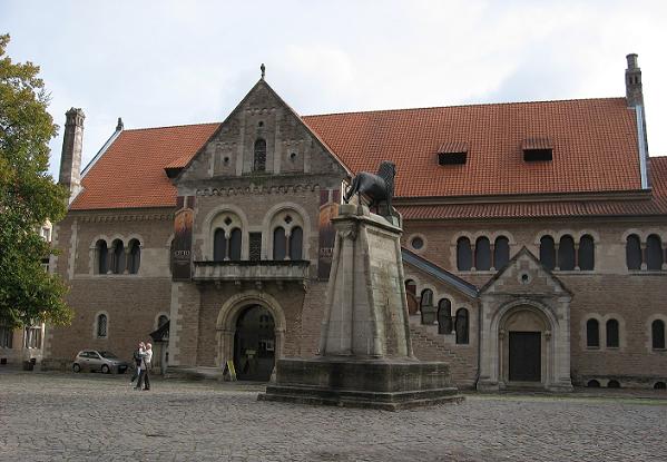
    Dankwarderode Castle in Braunschweig, main seat of the Welfen

    Let's have a look at part of Otto's family tree which is another of those wonderfully tangled messes involving the nobility of half of Europe. We'll go back to our friend Heinrich the Lion, Duke of Saxony, one of the most interesting members of the Welfen dynasty. As some of you may remember, he was married to Mathilda of England, daughter of Henry II and Eleanor of Aquitaine. Their youngest son was Wilhelm (1184-1213), the later Duke of Lüneburg, also known as William of Winchester because he was born during Heinrich's exile at the court of his father-in-law.

    Wilhelm married Helena of Denmark, a daughter of Valdemar the Great. They had a son named Otto (1204-1252; nicknamed 'the Child' to distinguish him from his uncle, the Emperor Otto IV). Otto married Mathilde of Brandenburg, a daughter of Albrecht II Margrave of Brandenburg and Mathilde (yes, I know *sigh*) of Lusatia - she brings a Polish connection into the mix since her mother was Ełżbieta of Poland, daughter of Miesko III of the Piast dynasty.
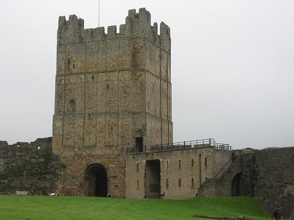
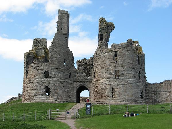
    Sichelnstein Castle, one of Otto's border fortifications

    I'm only going to follow the offspring that matters for the line leading to Otto the Quarrelsome, and that is Otto's and Mathilde's son Albrecht I of Braunschweig who married one Adelaide of Montferrat and had a son named Albrecht as well, Albrecht the Fat (1268-1318). At that point the Welfen possessions had been split to provide for more than one son and thus he was known as Albrecht of Braunschweig-Wolfenbüttel-Göttingen, and he was the first to take his seat in Ballerhus Castle (no longer in existence) in Göttingen.

    Albrecht married Rixa of Werle, a granddaughter of Earl Birger Magnusson of Sweden and with her he had a football team of kids. One of them was Ernst (1305-1367) of Braunschweig-Göttingen, who married Elisabeth of Hessia, daughter of Heinrich II Landgrave of Hessia and Elisabeth of Thuringia (who in turn, was a granddaughter of Albrecht of Thuringia and Margarethe of Staufen, mentioned in this post). Otto the Quarrelsome was their son. The Hessian descendance of his mother will play a role for Otto later.

    (Sichelnstein, view from the gate to the inside)

    Otto had a problem for starters: the hodgepodge structure of his lands which consisted of disconnected bits from the Solling and Uslar in the north-west to Gandersheim in the north-east, Northeim in the centre, Göttingen and Hannoversch-Münden in the south; plus a number of castles. Nor were his lands particularly rich; which may explain Otto's constant money problems - they may not always have been due to his excessive feuding.

    So of course Otto was looking for more and better lands. When Landgrave Heinrich of Hessia's son, another Otto, died childless, Heinrich at first named Otto the Quarrelsome, who had a claim through his mother, as heir. According to the still active Salian law, allodial possessions could be inherited via the female line. But Heinrich changed his mind in 1367 and proclaimed his nephew Hermann as heir instead. Otto probably had made too true of his nickname, and the altered succession left him in a really foul mood.

    Otto was not the only one who disliked the expansionist politics of the landgraves of Hessia. He joined up with a group of discontented nobles in the Star League (Sternerbund), founded in 1370. The league was led by Otto and the Counts of Ziegenhain-Reichenbach, Gottfried VII and his son Gottfried VIII, who were one of the main targets of the expanding landgraviate of Hessia. Among the members were a number of nobles, mostly from Hessia and the borderlands (including the Hanstein family), and several ranking clerics, the highest among those Archbishop Johann de Ligny of the Electorate Mainz who didn't want to lose his position of most powerful man in Hessia to Landgrave Heinrich.

    The founding meeting - in 1369 - took place in Ziegenhain Castle, and the sign of the alliance, a six pointed star, derived from their arms. The league could call upon 2000 men in arms and, among them, held some 350 castles. The Star League was only one among several like alliances that were established among German nobles and knights at the time, but it's the one important for the area I'm writing about here.
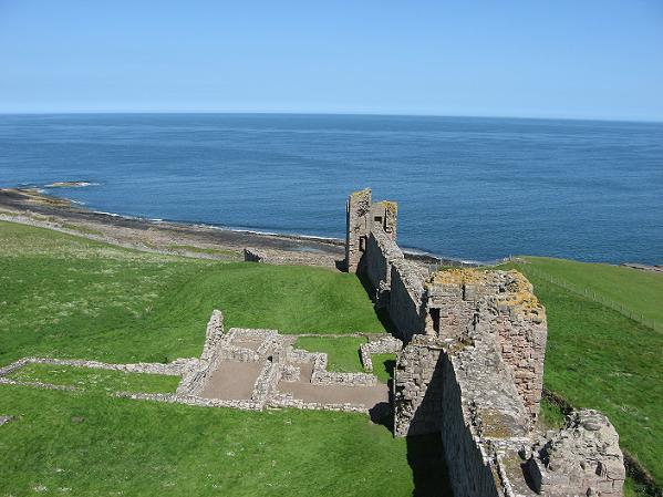
    Another view of the Sichelnstein

    Otto's aim may not have been to get the entire landgraviate of Hessia (he was likely realistic enough to understand that his claim was less strong than Hermann's and he'd have needed support from inside the family), but he was at least looking to get the bits and pieces of Hessian possessions sitting between his own lands south of Göttingen, and create an united area between Leine and Werra. Moreover, his sister Agnes was married to Gottfried VIII of Ziegenhain, and Otto was still behind on paying her dowry. Acquisition of more land and income would have solved that problem. Though their union, and shared command, in the league shows that both men obviously got along despite the dowry issue.

    (Sichelnstein, the north wall; with my father walking along it to compare size)

    Landgrave Heinrich of Hessia didn't sit idly by while the Star Warriors charged their light sabers. He looked for allies in turn and found one in his nephew Friedrich of House Wettin, Landgrave of Thuringia and Margrave of Meissen (his father, another Friedrich, was the brother of Heinrich's wife Elisabeth of Thuringia; see above). Both families concluded a mutual protection and support alliance, and more important, a heritage confraternity. That meant that one family would inherit the possessions of the other if it died out in the male line. Since the families were related, there would always be some claim, and the confraternity now overrode all other claims. That of course, put an end to Otto's hope of inheriting any Hessian lands. It also gave Heinrich the military strength to face Otto's alliance succesfully.

    The Star War broke out in 1372 with the usual tactics of destroying mutual properties and besiegung / sacking a few castles, but there never was a pitched battle. Landgrave Heinrich's troops won a number of those encounters and eventually, the Star League began to lose its points by nobles conducting separate peace negotiations with Heinrich.

    In 1375, the emperor Karl IV confirmed the heritage confraternity, the allod of Hessia, and Heinrich's and his successors' entitlement to the fief of Thuringia, at which point Otto negotiated as well and renounced his claim to Hessia in exchange for some financial compensation (I wonder if he paid the dowry then). This was the end of the Star League. The position of House of Hessia was considerably strengthened by these developments.

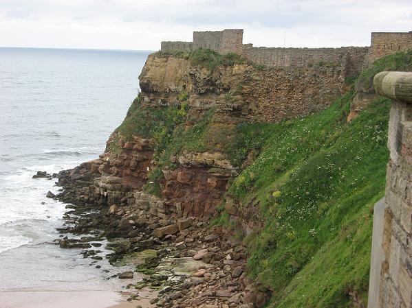
    Two of the castles that were involved in the small scale fighting actions going on during the Star Wars were the Sichelnstein I already posted about, and the Sensenstein.

    The only remains of Sensenstein Castle; part of the wall and trench fortification

    That's pretty much all that remains of the Sensenstein today. While the Sichelnstein had been around for several centuries and was only refortified by Otto, the Sensenstein was a new castle built by Hermann of Hessia, co-regent with his uncle Heinrich, in 1372. The name was a bit of a jibe - Sichelnstein means Sickle-stone, and Sensenstein is Scythe-stone. Hey, I got the bigger one. *grin*

    Otto used to send out raiding parties from Sichelnstein Castle, and the garrison of the Sensenstein tried to prevent them form invading Hessian territory, but I didn't find any details about those raids except that they were connected with the Star Wars.

    The next time Sensenstein Castle is mentioned in chartes includes a transaction with the family of Berlepsch, vassals of the landgrave of Hessia, in 1438, but the castle was returned to the landgrave in 1461; he used it as hunting lodge. But the castle fell into decline and in 1585, a manor was all that remained. So when it comes to survival, Sichelnstein Castle won, though Otto did not. ;-)

    The monastery church at Wiebrechtshausen, burial place of Otto the Quarrelsome

    The next post will be about Otto's involvement in the Lüneburg succession war and his feud with Göttingen.

    * The name is sometimes translated as Otto the Evil but I think 'evil' is too strong a word to characterise him.

    Sources:
    Edgar Kalthoff; Geschichte des südniedersächsischen Fürstentums Göttingen und des Landes Göttingen im Fürstentum Calenberg 1285-1584. Herzberg, 1982
    Olaf Mörike, Göttingen im politischen Umfeld: Städtische Macht- und Territorialpolitik. In: Dietrich Denecke, Helga-Maria Kühn (ed.),Göttingen: Geschichte einer Universitätsstadt, Volume 1. Göttingen 1997; page 260-293

    Book Tower

    $
    0
    0

    Fantasy author Mark Lawrence has asked the readers of his blog to post photos of book towers they created. Well, it sounded like a fun thing to do and so I started hauling Roman themed books, both fiction (easy) and non-fiction (not so easy - I've got some real monsters there; the boxed set of the 2009 Varus Exhibition catalogue weighs in at 6 kg), from the shelves in my flat and created this.

    The twin towers of Roman books

    Of course, after I had taken the photos and dismantled the tower, I remembered another shelf which held, among others, some German fiction about the Romans and my bilingual editions of Ovid and Vergil. Well, the whole thing looks pretty impressive anyway (the yardstick leaning against the tower shows 1 metre).

    And yes, I know some of you will want to peek at the titles. Here we go.

    Otto the Quarrelsome: The Lüneburg Succession War

    $
    0
    0

    Otto the Quarrelsome had a thing for heritage succession wars, it seems. He had barely solved the first round of the Hessian mess - or rather, it was solved for him - when he got himself embroiled in the war about the heritage to the duchy of Braunschweig-Lüneburg. Well, this time it sorta remained in the family and Otto acted on behalf of his cousins once removed; at least that was the reason he gave.

    Braunschweig, Dankwarderode Castle at night

    OK, let's go back on those geneaologies a bit. We remember that Albrecht I of Braunschweig-Wolfenbüttel was the father of Albrecht the Fat who had a bunch of sons with Rixa of Werle. One of those was Ernst (1305-1367), the father of our Otto, another was Magnus (1304-1369; married to Sophie of Brandenburg of House Ascania), who had a son Magnus (you guessed that, right?), nicknamed Torquatus, who in turn had several sons, among them Friedrich and Bernhard - Otto the Quarrelsome's cousins once removed.

    For the next step, we need to go back to Albrecht I again who had a brother, Joahnn of Braunschweig-Lüneburg; aka Old House Lüneburg. He was married to Liutgard of Holstein and had a son named Otto the Strict, who married Mathilde of Bavaria with whom he had several sons, among them another Otto, and Wilhelm. Those two brothers shared in the rule of the duchy, and Wilhelm (1300-1369) continued alone after Otto's death. But both brothers didn't manage to produce a surviving male heir, though Wilhelm had a daughter.

    Braunschweig Cathedral

    You still with me? Good. *hands out brownie points* Well, after the death of Wilhelm, there were several candidates for the succession, among them Albrecht of Sachsen (Saxony)-Wittenberg, the son of Wilhelm's daughter Elisabeth and Otto of Sachsen-Wittenberg († 1350) of House Ascania; and Magnus Torquatus.

    Like the Welfen, the Ascanians were an old family whose documented origins date back to the 10th century, and there was a bit of a rivalry between both families. The Ascanians, too, had split into several lines; one of them were the prince electors of Sachsen-Wittenberg.

    Emperor Karl IV considered the Lüneburg fief as fallen back to him, and he wanted to decide who'd inherit it. His pick was Albrecht who was supposed to rule together with his uncle Wenzel (Wenceslas; a younger brother of Otto). Magnus Torquatus did not like that and tried to remedy matters at the head of an army of knights and squires. The towns of Hannover and Lüneburg declared for Albrecht (the Welfen politics wasn't exactly town-friendly) and so there soon was a full-fledged war. Magnus fell in battle in 1373, leaving behind two young sons, Friedrich (born 1357) and Bernhard.

    Braunschweig Cathedral, crypt

    After Magnus' death, peace negotations were conducted and Magnus' widow, Katharina of Anhalt-Bernburg, married Albrecht who was going to rule the duchy, while her sons Friedrich and Bernhard married daughters of Wenzel and kept a claim to Braunschweig-Lüneburg via possible offspring.

    But Otto the Quarrelsome took the chance to intervene on behalf of his cousins and indeed managed to gain Braunschweig, the main seat of the Welfen. He played a net of alliances no one really followed but he did rule Braunschweig from 1374-1381. The town didn't like that much - Otto had a talent to not get along with towns - and would have prefered Albrecht. And then Friedrich also stood up against his guardian and started making political moves of his own, conquering Lüneburg in 1388.

    In the end, Otto renounced his claim in exchange for money as he did in Hessia. Friedrich would become Duke of Braunschweig-Lüneburg in 1389 and keep those lands in the hands of the Welfen.

    The walkway between the castle (left) and the cathedral, used by the ducal family

    Friedrich was assassinated upon return from the imperial elections in Mainz in 1400. The man behind it was a sheriff of the archbishop of Mainz, Count Heinrich VII of Waldeck. Friedrich and the archbishop had quarreled about who was to become the next German king after several dukes has ousted Wenceslaus 'the Lazy' of Luxembourg. The archbishop's candidate, Elector Palatine Rupert, won that election. And here's another English connection: Rupert's son Ludwig (Louis) was married to Blanche of England, daughter of Henry IV.

    The duchy of Braunschweig-Lüneburg went to Friedrich's brother Bernhard whose offspring continued the Middle House Lüneburg-line.

    The church of Wiebrechtshausen,
    view into the burial chamber of Otto of Braunschweig-Göttingen

    I should continue with Otto's quarrels with Göttingen, but I don't have any photos of my hometown to go with it, and right now there's a big hole with busy moxies in front of the town hall and the church founded by Heinrich the Lion is hiding behind a scaffolding. I should have done a photo tour long ago but somehow the own place can always wait.

    Pilot Boat

    $
    0
    0

    Just a little something today. Pilot boats were a constant feature during last year's cruise since pilots were required to navigate the harbours, rivers, the Stockholm archipelago and other tricky waters. And those little red things were fun to watch.

    Pilot boat arriving, full speed ahead

    I took those photos in the Stockholm archipelago on a late but still sunny evening.

    Another shot

    It was literally dancing on the waves. Very pretty.

    Going alongside

    So you can compare size. Shot taken from the aft deck of the Albatross.

    And leaving

    This one was fetching the pilot which another vessel had brought onboard earlier.


    The Imperial Palatine Seat Tilleda - Fortifications

    $
    0
    0

    I have mentioned Tilleda a few times already since it's one of the rare examples of a Medieaval palatine seat of which more remains than some crumbled earthen walls and a sign. Werla, albeit double the size of Tilleda shows only a few of those today, Grona has become a suburb of Göttingen, in Pöhlde only some foundations remain. Of course, most of what we can see in Tilleda today has been reconstructed - earthen walls and wattle and daub houses don't preserve well - but it is the only complete complex of the sort. In Goslar, only the great hall has been restored, albeit it is a most splendid example.

    Tilleda, gate of the outer bailey. The way it is drawn in between the walls enabled the defenders to throw all sorts of pointy, hot, or otherwise interesting things on attackers.

    Tilleda is first mentioned as Imperial Palatine seat (imperiatoris corte) in a charte dating to 972, where it is listed among the lands Otto II gave his wife, the Byzantine princess Theophanu, as dower. But the castle on the Pfingstberg hill must have been in existence since the early 10th century.* Tilleda surely was part of the net of palatine seats in Thuringia and Saxony already at the time of King Heinrich I.

    Palatine seats, sometimes also known as royal vills in England, were needed because the king had to show his presence to the people, taxes paid in food could not be transported and stored over long distances, so Mediaeval kings did a lot of traveling and wanted to stay in places of some comfort.

    Outer gate seen from the inside with some wattle and daub houses in the foreground

    The Pfingstberg hill lies north of the Kyffhäuser mountain ridge, a place that has become famous for the legend of the emperor Friedrich Barbarossa sleeping deep inside the mountain to return in time of great need. So far, no one has seen him, but he got a big, kitchy 19th century monument on top of the mountain. If that didn't wake him from of his sleep; I doubt anything will. *grin*

    There are the remains of a 12th century castle halfway down the mountain as well, but when we got there, it turned out the restaurant at the monument hosted a major biker meeting and there were bikers everywhere in addition to the usual avalanches of tourists on a sunny day, so we decided against trying to find a parking lot only to photograph some ruins with a lot of people blocking the sights.

    View from the gate to some houses, with the Kyffhäuser in the background

    The seat of Tilleda has a trapezoid shape and covers an area of 5.6 hectares (about 350x250 metres). The part of the hill where the main castle is situated has steep slopes that fall down 25 metres on three sides, on it were additional fortifications in form of a trench and wall, partly of stone, partly timber palisades. Only to the west the land is flatter (but still some 10 metres above the surrounding terrain); there the outer bailey lies, once protected by walls of mortared ashlar (see below). Another, second outer bailey on the southern terrace near the river Wolwede has been excavated but not reconstructed.

    The ground of the hill is sandstone on a layer of Zechstein gypsum which led to a rockfall probably in the early 11th century which destroyed part of the main hall in the northeast corner of the castle.

    Interior of the outer gate, with my father looking out for enemies

    The castle with the main hall, church and living quarters for the nobles - several of them with hypocaust heating - is separated from the outer bailey by a system of walls and trenches. Most of the buildings in the main castle were made of stone, or at least had stone foundations, though the hall was rebuilt as pillared longhouse after the rockfall. I will get back to the remains of those in another post.

    The main wall with the palisades and the gate - in its second, stone version with timber upper storey - have been reconstructed, as well as one of the trenches.

    Inner gate, seen from the outer bailey

    The area between the main castle and the outer bailey had during Ottonian times served as some sort of middle castle with a granary and the living quarters of the chatellain / administator, but later, the fortifications were considerably strengthened. Maybe the defense purpose of the place became more important during quarrels between kings and nobles. King Lothar of Süpplingenburg destroyed the castle on the Kyffhäuser in 1118, for example.

    We can trace a sojourn of Emperor Friedrich Barbarossa in Tilleda in 1174, and in 1194, Heinrich VI received the exiled Heinrich the Lion in reconciliatory meeting. Considering the symbolic element inherent to such actions in the Middle Ages, it proves that Tilleda was an important place; such meetings didn't take place in some backwater village.

    Inner gate seem from the remains of the church

    The outer bailey, encompassing about 60% of the entire site, is the most typical feature of the palatine seats of itinerant rulers. This large outer bailey was protected by a wall of mortared ashlar, both of local origins (some of the gypsum pits have been excavated). These walls have later been used as quarry and were only partly reconstructed; the rest of the layout is marked by a low earthen wall. The original height of the ashlar wall is unknown.

    There were a lot of houses, mostly of the wattle and daub type, but also some timbered ones, and a number of pit houses. They served as workplaces, storage huts, and living quarters for the people involved in producing pottery, weavings and iron products on which this particular seat obviously specialised.

    Rampart with access from the inner bailey

    The fact that the reconstruction concentrated on those parts of the castle may be due to Tilleda having been a site in the former GDR where the interest in the working classes was much greater than in the kings. I don't know if there are plans to rebuild the royal hall as well though it would be nice.

    The palatine seat has been abandoned by most of its inhabitants in the 13th century. Its purpose as housing for itinerant kings became useless when those prefered to live in the better fortified hilltop castles, and the various industries moved down to the Golden Valley (Goldene Aue) where the conditions obviously were more favourable.

    View from the inner gate to the Kyffhäuser, with a pit house in the foreground

    I'll get back to that unique place and show you some of the buildings next time. Some of them house Medieaval tools (looms and such) and give some glimpse of life in the 10th/11th centuries.

    * Chartes issued in specific places and the mention of sites in chartes only give very incomplete information about those sites since much depends on chance of both historical events and preservation.

    Sources:
    Hans Eberhard, Paul Grimm. Die Pfalz Tilleda am Kyffhäuser - Ein Führer durch die Geschichte und Ausgrabungen. Halle/Saale, 2001

    I'll Be Away

    $
    0
    0

    Until midst of June, hunting some more castles and churches. But I won't leave you without some photos to tide you over.

    Entrance to the harbour of Newcastle (seen from Tynemouth) - my usual way to the UK

    I got several castles on my list, as I mentioned a few weeks ago. I'm looking forward to Bamburgh and Alnwick especially, and Dunottar - that one looks like the sort of Let's See If We Can Put a Castle Here The Wind Won't Blow Away.

    Edinburgh Castle

    There should be some churches, too (Whitby fe., if I can sneak it into my schedule). I also really hope the weather and the tides will allow me to visit Lindisfarne. The same goes for some of the places on the Orkney (like Birsay).

    Inchcolm Abbey

    Let's also hope I packed the right stuff. I do pack for every weather but if the same ol' rain stays put for two weeks, I may run out of dry stuff nevertheless. Well, right now the same ol' rain is pretty busy in Germany and that's where it can stay as long as I'm not there. Lol.

    The Castles, Part 2 - Other Castles I Visited

    $
    0
    0

    Here's a sneak peek into the other castles I visited this time.

    Richmond Castle, the keep

    Richmond Castle is one of the oldest Norman castles of which parts still remain.

    View towards Scollard's Hall and Gold Hole Tower, with the Fallen Tower to the left

    Quite substantial parts, as you can see. Richmond Castle was the kernel of the large Honour of Richmond that would play a significant role in history.

    Warkworth Castle, the keep seen through the gate of the Lion Tower

    Warkworth is another of the Percy of Northumberland castles. They kept collecting those. :-)

    View from the keep to the eastern hall range

    It's a beautiful, picturesque ruin I enjoyed very much.

    Bamburgh Castle, seen from the land side

    The famous Bamburgh Castle. I could not get the seaside view you find on every book about Northumbria, but I got some decent pics nevertheless.

    The Keep (one of the original Medieaval buildings)

    Bamburgh has been rebuilt in Victorian times, and I must admit that some of the architecture jars a bit. The Wartburg reconstruction is more in style, imho.

    Dunottar Castle, sitting on a cliff

    A cliff, a knife edge way that's closed to the public, and lots of stairs down one hill and up the other. Constance may try her best with Dunottar Castle, hehe.

    The way up along the outer curtain wall

    Did I say: stairs, lol? And those likely weren't around in former times.

    Urquhart Castle, view to 14th century keep and gatehouse

    I visited Urquhart Castle in 1998, but I wanted to go back with a digital camera since I had fond memories of the place.

    View to the 12th century part of the castle

    There is a new visitor centre now, and lots more tourists. Just well they start getting dinner-hungry long before the castle closes.

    The Castles, Part 1 - For My Friends

    $
    0
    0

    I'm back and over the next days I will present the usual photo overviews. The weather wasn't bad; in fact, the rain stopped during my way up to Scarborough Castle (my first place to visit) and never came back while I was traveling around. Must have been scared of me, lol. Several days were even warm and sunny, though Orkney was a bit on the grey and windy side.

    Without further ado, here are a few castles I visited with special interest of some readers in mind:

    For Anerje: Scarborough Castle

    Scarborough Castle; the keep seen from the outer gate

    No wonder the Earl of Pembroke tried to coax Piers Gaveston into surrendering; laying siege to that place would not have been fun. And with the wind like the day I visited it would have been nasty and cold, too. You owe me a cookie or two for braving that wind. *grin*

    The curtain wall on the town side

    Look at those walls and the steep slope in front of them. I know what I talk about; I walked the blooming path all the way to the top. And there I had thought only German castles sat on hilltops and cliffs. ;-)

    Scarborough Castle seen from the northern beach

    I took this one a few days later on a sunny evening when the sea fog was just coming in with the tide. The atmosphere became a bit mysterious, but I didn't see a headless Piers. Or one with a head.

    For Kasia: Alnwick Castle

    Alnwick Castle, the inner bailey seen from the outer one

    Alnwick (pronounced something like 'Annick') Castle is still the residence of the Dukes of Northumberland and thus some features have been altered over time. But the overall layout of the bailey is still the original one.

    The Barbican

    The barbican is one of the old buildings that was around already at the time of William the Lion (albeit the figures were added by one of the duchesses later). Maybe he even entered the castle through this gate. No plaque or anything though, the focus lies more on the later Medieaval history of the castle and the Victorian state rooms.

    The inner bailey from the inside (the Norman entrance is to the right)

    Alnwick Castle is also a place where you can meet Mrs. McGonagall on occasion, and a bunch of wannabe wizards on broomsticks. Some scenes of the Harry Potter movies have been filmed there and there are Potter-y events for kids.

    For Kathryn: Dunstanburgh Castle

    Dunstanburgh Castle in the evening sun

    I was lucky to find a castle I didn't have on my list but which fit into my schedule quite well and which turned out to be connected to Thomas of Lancaster and fell into King Edward's hands after Lancaster's execution. So you'll get your castle as well. *grin*

    Closeup of the keep

    Lancaster built that one after his relationship with Edward II detoriated. It sits in sight of Bamburgh Castle (at least on a clear day) and there was an element of 'neiner, neiner' to the place which the duke actually never lived in. He was caught before he could flee to Dunstanburgh.

    View from the keep towards Constable's Tower (in the middle) and Egyncleugh Tower (close to the sea)

    It's a lovely ruin I had a lot of fun exploring. Even though I got a sunburn on my nose for a change.

    More castles are below. Some abbeys as well and a bunch of Pictish and Neolithic sites will follow tomorrow. I've been a busy little photographer. :-)

    The Abbeys and Cathedrals

    $
    0
    0

    I got some abbeys and cathedrals, too; a few famous ruins among them.

    The Abbey of Whitby in the mist.

    Yes, there is a ruined church there - Whitby

    Not the usual tourist website photos, I'm afraid, but they may be more realistic than the sunny ones. I'm sure Hild would have known a lot of that fog.

    I had much better luck with the weather when I visited Rievaulx Abbey

    Rievaulx Abbey

    Rievaulx is grand. It must have been a huge and busy place once and even the ruins are still impressive. Most remains of the church, but there are some considerable traces of the other buildings as well.

    Rievaulx Abbey, remains of the main nave

    I spent quite some time there photographing and then went on to another church that's not a ruin: Ripon Cathedral.

    Ripon Cathedral, the nave between west work and transept

    There's a difference to German churches in the flat-roofed west towers, the larger crossing tower, and often the length of the nave on the side of the apse as well.

    I had to wait out a funeral service for the interior shots, but I got some eventually.

    Ripon Cathedral, view from side nave to the crossing

    Ripon has a long and interesting history and I got more research set out for me. *sigh*

    And there is lovely Lindisfarne

    The Abbey of Lindisfarne

    Less imposing that Rievaulx but a charming place, esp. in the sunshine. I was lucky to catch a low tide so I could get a taxi to drive me over.

    And a big church in a small town, the St.Magnus Cathedral in Kirkwall.

    St.Magnus Cathedral, Kirkwall, west front

    This one is a fine example of Romanesque architecture. I especially loved the interior with its sturdy, red columns.

    St.Magnus Cathedral, main nave

    Luckily, Henry VIII never got that far. He left enough ruins in his wake as it is. Though they are nice camera fodder. :-)

    Neolithic Remains, Picts and Vikings

    $
    0
    0

    Orkney was a veritable centre of Neolithic buildings, from the intriguing stone settings to a settlement like Skara Brae - a village older than the pyramids which has become one of the main tourist attractions.

    Skara Brae, a Neolithic settlement on Mainland Orkney

    Stone circles are very photogenic. The Ring of Brodgar may be less impressive than Stonehenge, but it's a lot more atmospheric. Especially with those dramatic clouds - though it never rained, fortunately. There's another, smaller stone setting, the one of Stenness, which I also managed to sneak in.

    Ring of Brodgar, a detail shot

    An then there's Maes Howe, the large cairn we are not sure what it really was; temple, burial place, meeting room....? You can only get inside on a guided tour and photographing is officially not allowed. *wink*

    Maes Howe, also on the mainland

    Definitely used for burial were the chambered cairns. Several fine examples can be found on the island of Rousay. Here's the largest one. I also visited a much smaller one you need a torch and a ladder to get into.

    Chambered cairn on Rousay

    Cairns can be found elsewhere in the Highlands, too, like the Clava Cairns near Inverness which come complete with standing stones and all. They're about 2.5 miles walk from the battlefield of Culloden.

    Clava Cairns

    But Neolithic remains are not the only fun thing to be found on Orkney. There are some nice Pictish brochs, too. Well, remains of brochs; they used to be much higher. Here's the Broch of Gurness.

    Broch of Gurness, Mainland Orkney

    They often come attached with the remains of settlements, though the latter was much smaller around the Broch of Midhowe than in case of Gurness. A lot of those places are off the roads and bus stops so I had some walking to do. :-)

    Broch of Midhowe, Rousay

    I was lucky again with the tide and could put a visit to the Viking settlement on Birsay into my schedule. Orkney had been in Norse possession for centuries and they left their traces behind. I've also taken a few pics of some smaller places like the round church in Orphir.

    The Viking settlement on Birsay

    In one case I was out of luck: since the tourist office in Inverness gave me the wrong opening times for the Pictish museum in Rosemarkie, I missed that one. Well, the booty was large enough for two weeks.

    The Most Popular Post in the Roman Empire - The Signal Station at Scarborough

    $
    0
    0

    If you like a desolate place with lots of cold wind, rain and fog, that is.

    But, Aelius Rufus, is has a splendid view over the bay of Scarborough and the sea. And with the hot summer we got right now, I would not mind some cold wind.

    So that's why you haven't been blogging. Spent all the time in the baths, eh?

    I wish I could have, Aelius Rufus. We could have met there. *grin* I admit I did spend some time on the balcony, but mostly it was work. You know how that is.

    View towards the remains of the signal station and the chapel (left)

    I do. *sigh* But back to the splendid view from the signal station. Hah, there was fog all over. I remember you muttering that it won't be of any use to catch the view with that little picture box since all there would be was a white blob. And that you should have brought your gloves because of that icy blast. Makes you wonder if the signal stations could see each other in the first place. Merlinus told me there had been a chain of signal stations along the Yorkshire coast all the way from Filey, Scarborough, Ravenscar, Goldsborough and Huntcliffe, and maybe one at Whitby as well, to warn of Pictish raids, and another chain down in the south, called the Saxon shore.

    Yes. The stations down in the south are a bit earlier, late 3rd to early 4th century, while those in the north date to the later 4th century. The one at Scarborough was built AD 360 or 380. And I admit, it's an uncomfortable place on a dreary day. But don't tell me the officers tell you the truth about any post they deploy you to.

    Overall layout

    No, and nor would they have told us that the place had run out of wood to feed the signal fire and the Picts were going to attack again. And that the next Roman fort is in Eboracum.

    Yeah, that's not exactly close, not even in present times, certainly not with British public transport. But the situation of the signal station is sound from a military point of view. On top of a cliff on a headland stretching out into the sea, with a well, and offering a view to the coast north and south of it, and a harbour basically at its foot.

    If there ever was one. My time traveling friend Merlinus - whom I asked because that signal station dates past my time - didn't find any proof, and nor did those archaeologists from your time. There are only some arguments that logically, there should have been a harbour.

    Another overview, with the gate to the left

    Too bad that the observations of your time traveling friend won't be accepted by either archaeologists or historians. It would solve a few research hassles. The problem is that part of the cliff crashed down at some point, cutting off the eastern end of the signal station, and we don't know what it may have buried and washed into the sea. The first undisputed traces of a harbour indeed date to the 12th century and coincide with the first establishment of the stone castle on the headland (1157-1164).

    So your knights liked cold and dreary places, too, eh?

    As did the AngloSaxons, Aelius Rufus. They built a chapel on the remains of the signal station about AD 1000. Which makes for the mess of foundations you can see today.

    I guessed someone had tampered with the place. The Romans would never have built anything so asymmetrically, you have to give them that. Only the square of walls - well, mounds rather, nowadays - and ditches still displays a decent Roman pattern.

    Closeup of the ditch

    And the gate; those foundations are Roman, too. So let's show our readers what a 4th century Roman signal station, standard version, looked like. The ditches and earthen walls surrounded a courtyard of about 33 square metres (about 100 feet) which was in turn protected by a wall, usually timber palisades on a stone foundation, with D-shaped watch towers in each corner. Some later ones were built all in stone. Inside this sat the square tower that held the signal fire on its top. You can see the layout better on this aerial photo (from the Roman Britain website).

    Now there's an interesting picture. How on earth do you get those; don't tell me people in your time can fly around with those picture boxes.

    Oh yes, we can. But it needs an aviation machine and those are terribly expensive even to hire, so I won't take any aerial photos. But the army uses them to transport soldiers and equipment, for example. You can also hire a seat in one if you want to travel long distances.

    Wow, that would have saved our legates some headaches.

    Remains of the gate house

    The foundations of the tower proper - 45-50 feet square - were around four and a half feet thick and the tower may have been about 20 to 25 metres high. Later, some towers were strengthened to eight feet thick walls and could be about 100 feet high.

    Feet and metres, can't those Brits not decide for one?

    Not in their guide books, it seems. And I'm too lazy to do the conversions. There are post holes which points at timber platforms inside the tower, but the garrison didn't live in the tower but in barracks in the yard between tower and outer wall. Some signal stations, like Ravenscar ten miles north of Scarborough, had a fortlet attached - it's remains are now hiding under a hotel.

    Too bad, that way your archaeologists can't get at them. So, what happened after the Romans left Britannia?

    The well

    The signal stations fell into decline if they were not used for different purposes. As I said, there are remains of an AngloSaxon chapel dedicated to St.Mary, dating to about AD 1000. The well on the premonotory may have played a role in chosing this place, as well as the Roman stones. The chapel has been altered in later times and was still in use when the castle was inhabited. Other places like Ravenscar were destroyed by Viking raiders, but there's no archaeological proof for such an incident at Scarborough. They may have plundered the chapel, but they did not destroy it.

    Roman walls will withstand Viking axes, maybe. I suspect it was the endless rain that brought down the place. *wink* And that landslide you mentioned.

    Yes, coastal erosion is a problem for a lot of sites, not only in Northumbria.

    View from the northern corner, with the curtain wall of the castle in the background

    So, dear Gabriele, you did not visit any more Roman sites this time?

    Unfortunately not. Aldborough was closed, and there is no Roman presence on Orkney.

    Can't blame them. Even more wind and more rain.

    Well, wind there was, but no rain while I was staying there. But I got some Pictish brochs for you.

    Then better don't wait a month again to what's it called, ...update this blog.


    I did Something Crazy

    $
    0
    0

    And got me a Twitter accout. Because the internet totally needs another bird chirping, lol. But it does get you in contact with people. Here's the link to my site,

    The coast of Northern Norway

    To go with the heat outside, here are some cool photos, taken during my Norway tour in 2011. The place looks really inviting right now, at least to me.

    April beyond the Polar Circle

    Now I need to figure out how to post photos and those shortcut links on Twitter. Damn time sink. :)


    Neolithic Orkney - The Ring of Brodgar, Part 1

    $
    0
    0

    Orkney is rich in Neolithic sites, and the area between the Ring of Brodgar, the Standing Stones of Stenness, and Maes Howe in particular so. On the landbridge separating Loch Stenness and Loch Harray, the Ness of Brodgar, a Neolithic settlement is being excavated, with cool new finds popping up almost daily. Those guys and gals must love playing in the mud right now. *grin*

    Partial view of the Ring of Brodgar

    The Ring of Brodgar is the most visible and iconic of those Neolithic sites. It makes for splendid photo motives, too; I got too many to cover by one post. So I'll give you some general information about the ring here, with another post about the role of the site in Neolithic Orkney to follow.

    Part of the ring seen from outside

    The interior of the ring was disturbed by peat harvesting and has never been excavated. Therefore the monument was not scientifically dated, though it is generally assumed the Ring of Brodgar was built between 2500 and 2000 BC, which puts it in the later period of Neolithic activities on the site. The Standing Stones of Stenness on the other side of the causeway are much older: 5400-4500 BC).

    Another view

    The Ring of Brodgar has a diametre of about 104 metres (340 ft). Only 36 stones remain today, but there may have been as many as sixty stones once. Several of them had fallen and were re-erected in the 19th century. They vary in heigth from 7 feet (2 metres) to 15 feet (15ft 3 in - 4.7 metres) and are thus smaller than the Stones of Stenness. But the ring itself is pretty large and comes third in the British Isles, after Avebury and Stanton Drew. The famous Stonehenge site is actually a bit smaller than the Ring of Brodgar.

    The two largest stones

    The Ring of Brodgar is enclosed by a rock-cut ditch that brings the diametre to 130 metres. It is crossed by two causeways; a smaller on in the south-east, and a 3.4 metres wide one in the north-west. Interestingly, there is no outer bank made of the material from the trench like at other rings. Some of the material may instead have gone into the several mounds that surround the Ring of Brodgar.

    Seen from the ditch
    (That path in the foreground is not one of the causeways)

    The name of the ring was recorded as 'Broager' in 1563, but the local Orcadian pronounciation always added a 'd' in the middle which has become part of the official spelling in 2004.

    Next time we'll look at the Neolithic landscape and culture of the place.

    Neolithic Orkney - The Ring of Brodgar, Part 2

    $
    0
    0

    The views of the Ring of Brodgar, framed by hills, with lochs on two sides, is very pretty, but it is not the original landsacpe.

    (The Ring of Brodgar)

    Sure, the hills were there already, but the area of what today is Loch Stenness instead was a marshy bog with pools of water. Makes one wonder how those Neolithic people managed to set the stones up on such tricky ground, but I suppose the spot they chose for the ring may have been less marshy; it is a bit higher even today. That still leaves the problem of transporting heavy boulders across mossy ground, but the Neolithic people must have solved it somehow (timber causeways and such would not leave any traces).

    The sea - still rising since the last Ice Age - breached the narrow landbridge about 1500 BC and created the saltwater loch of Stenness. The place where this happened is today the Brig o'Waithe in Stenness. The Ring of Brodgar had been around for at least 500, maybe 1000 years at that point. I wonder if there are silt-covered remains of Neolithic buildings at the bottom of the loch.

    The Ring of Brodgar is not the only henge in the area; I've already mentioned the Standing Stones of Stenness a mile to the south-east; but there is another ring north-west of Brodgar, the Ring of Bookan. This one is a massive earthwork with a ditch that surrounds an oval raised platform of 44.5 by 38 metres. The role of that platform is still disputed. It may have housed a cairn, or another set of standing stones. There are some stones within the ditch which could support the theory of both a ring or a chambered cairn, but the size of Bookan connects it with the Stones of Stenness - the area enclosed by the ditch and wall are of similar size.

    Ring of Brodgar, some stones with a view towards Loch Harray

    There are several solitary standing stones in the area as well, like the Comet Stone east of Brodgar or the Watchstone at the causeway near the village of Stenness. Add to this the settlements of Barnhouse and Ness of Brodgar as well as the cairn at Maes Howe, and you got a veritable time travel spot into the Neolithicum.

    View towards Fresh Knowe

    Cairns didn't get out of fashion any time soon. There are several cairns and mounds around the Ring of Brodgar some of which presumably date to the Bronze Age (South Knowe and Plumcake Knowe, where Bronze Age burial cists have been found). Fresh Knowe and Salt Knowe may be Neolithic, the latter with a secondary cist burial in the upper part of the mound.

    Another view of some stones

    Several of the stones in the Ring of Brodgar are splintered along their crystalline structure and it's not impossible that some of the fallen or missing stones may have lost their stability that way. Most of the stones used in the henges and other buildings derive from the Old Red Sandstone strata (which is not always red), which lends well to the forming of regular-shaped slabs; but limestone was also used.

    (One of the splintered stones)

    The question arises what exactly was the function of this complex of henges, standing stones, cairns, burial mounds and villages in such a small area (if we add the village of Skara Brae and Unstan Cairn, it's still only some ten miles around).

    The Neolithic people living on Orkney 5000 - 3500 years ago were the first to abandon the nomadic lifestyle and built settlements. Building henges of stones that needed to be transported over long distances by boat, or with ropes on timber rolls, took an enormous communal effort that could not have been achieved by just one village. About 80,000 man-hours went into the construction of the Ring of Brodgar alone. It is therefore assumed that there must have been some sort of hierarchial structure where some leaders could persuade people to work together to a common goal, and organise the work.

    The Rings of Stenness, Brodgar and Bookan are likely some sort of markers, visible in the landscape. Albeit there is no clear connection with the solar or lunar cycles like in Stonehenge, one can assume that those places served as gathering spots for festivals and rituals. The Neolithic people were able to determine those cycles as Maes Howe with its winter solstice orientation proves. The ditches of the rings and the entrance passage of Maes Howe also mark those sites as special places, likely taboo for most people outside the festivals.

    They may also have attracted visitors from all over Orkney. If those people walked along the path from the Stones of Stenness to the Ring of Brodgar, they would have to pass Barnhouse village and the Ness of Brodgar settlement, which should have lent some prominency to those.

    Another detail shot

    I'll get back to the cairns in another post (since I got extra photo material). They were more than just tombs, though bones have been found in most of them; they were the focal point for gatherings and ceremonies - likely mostly religious - much like churches are today. As such, they had their place besides the stones and henges. Since the active use of cairns survives into the Bronze Age, one may assume that the Ring of Brodgar and other sites may still have had a function then as well.

    Against the light

    The Ring of Brodgar was first mentioned by Jo Ben, probably a priest or traveling monk, in his Descriptio Insularum Orchadiarum in the early 16th century. The first research was done by the archaeologist and painter George Petrie and one Captain Thomas, among others, in the 1850ies, and is still going on today. There is much to discover yet.

    Sources
    Sally Foster: Maes Howe and the Heart of Neolithic Orkney, Historic Scotland Official Souvenir Guide. 2006
    The Orkneya website

    Weser Skywalk and Hannover Cliffs

    $
    0
    0

    Yes, we got a skywalk, too. Not as grand as the one in Colorado, but then, the Weser river and the Hannover Cliffs are no Grand Canyon. But the scenery is beautiful and pretty typical for the German mittelgebirge. And it's free and photographing is allowed, heh.

    View over the skywalk towards Bad Karlshafen

    The skywalk has been erected in 2011. It is anchored in the rock, made of zinc-coated steel with grillage floors; it has two levels with the lower one stretching 4 metres outward off the cliff. The grillage floor was a bit tricky for me since I don't take heights well, and you can see right down beneath your feet - 75 metres to the river and road. But I braved it.

    View from the upper platform to the lower one

    The Hannover Cliffs are close to the town of Bad Karlshafen, with the villages of Herstelle and Würgassen on the other side. In that area three German counties meet: Lower Saxony, Nordrhine-Westphalia, and Hessia; the place is known as the Dreiländereck. Bad Karlshafen is a Huguenot settlement. Herstelle - old name Heristal (= camping site of the host) - goes back to Carolingian times (AD 797), though the old abbey and the 13th century castle have been replaced by Baroque / 19th century buildings.

    View downriver towards Herstelle (left) and Würgassen (right) from the lower platform

    The skywalk sits on the easternmost of the seven Hannover Cliffs (Hannoversche Klippen) on the northern / right shore of the Weser and the southwestern fringe of the Solling mountains. They are named after their location in the former Kingdom of Hannover at the border to Hessia. The cliffs are a protected nature reservation today.

    View towards Herstelle and Reinhardswald Forest at sunset, with the skywalk railing in the foreground

    The Hannover Cliffs are red sandstone, much like the Hessian Cliffs on the other side of the river about a mile south-east, and belong to the same geological formation, the Triassic (~ 250-200 million years ago).

    The Triassic is distinguished by subsequent layers of red sandstone, musselkalk and black shale mixed with dolostones (Keuper) But that is only valid for the Germanic Bassin covering Germany and northwestern Europe; else the lithostratigraphical distinction is simply Lower/Early, Middle, and Upper/Late Triassic.

    (Detail shot of the sandstone cliff)

    At the time there was one continent - Pangaea - and the climate was mostly hot and dry, more humid along the Paleo-Thethys ocean coasts and in the polar regions. There were also monsoon events.

    A simplified version of complicated geological processes goes like this: The zechstein sea dried up and a system of north-running rivers left behind layers of sand which over time were pressed into sandstone by the weight of new depositions. Next the sea flooded into the bassin and added a layer of marine sediments - the musselkalk. When the sea fell dry, the rivers were left behind, still transporting material around; but there were also lakes that produced a layer of fine clay that hardened to shale. During the entire process salt was left behind in spots as result of the evaporization in the hot climate (the salt deposits along the Leine river were mined by the Germans in Augustean times).

    All these developments did not occur at the same level all over a diverse landscape, of course. There is no musselkalk layer above the sandstone strata at what today is the Weser - what there may have been, erosion took away when the ground was lifted. The Weser valley was cut out of the sandstone only during the last million years. Salt deposits inclused in the sandstone were washed out and weakened the rock in some parts; that's where the river carved its bed.

    Footprints of prehistoric reptiles (archaeosaurs, rhynchosauroids) that lived 245 million years ago in the valleys of the prehistoric rivers have been found in the red sandstone, while further upriver (in the grey sandstone) the fossils are mostly of flora, like equisetum species and pleuromeia, an extinct clubmoss.

    Hannover Cliffs, view downriver towards Herstelle

    Today, the cliffs are populated by trees in a mixed forest of beech and oak. Since the cliffs are too step, the trees are not felled for use but grow until they they fall by themselves - the forest is a bit of a jungle. The warm stones on the south-looking cliffs offer a home for butterflies and salamanders.

    Closeup of a bit of visible red sandstone cliff

    There are two different types of Weser sandstone: the red sandstone in the Karlshafen area (with inclusions of iron and haematite) and the grey sandstone further upriver around the Trendelburg. The sandstone has been used since the Middle Ages, and especially in building the palaces of the Weser Renaissance. It is still quarried in small scale.

    View towards Bad Karlshafen

    There are two ways to the skywalk, one from the river and one from above. The latter is less stressful. *wink* Though the way back to the car is still a bit uphill with a steep slope falling down one side. They put up a railing up parts, though.

    More Hiking Tours on the Hoher Meissner

    $
    0
    0

    Well, the conference that kept me busy the last weeks is over; I got some time off to recompense the overtime, and because of the fine weather those last days, we did some more hiking. Here are some photos.

    Pines on the High Meissner Plateau

    We did some tours in and around the Hoher Meissner last year but there's more to explore. The highest part of the Meissner proper is not a peak but a plateau that rises up to 754 metres. The mountain itself measures about 8 kilometres (north-south) to 4 km (east-west).

    Fine weather in autumn often means hazy air, but this view is still pretty scenic.

    View from the high plateau

    The geological history of the Meissner goes all the way back to the Variscan orogenesis about 350 million years ago, which is the foundation of most of the mountains in Germany (except for the Alpes). Traces of this stage can still be seen in the Devil's Valley (Höllental) with its 350 million year old diabase and greywacke formations.

    Diabase cliffs in the Devil's Valley

    Diabase is an igneous (solidified magma or lava; diabase is actually formed at a state in between) subvolcanic rock that emerged from the earth crust in underwater conditions. Greywacke is a very hard sandstone with an irregular structure and badly sorted inclusions of feldspar, quarz, and small pebbles. Both rocks are typical for the Variscan orogenesis.

    View from the Bilstein to the Devil's Valley

    The history of the rocks which I personally find rather interesting, aside, the views can be beautiful, like this one that was totally worth the climb.

    As mentioned in a prior post, remains of the 250 million year old dolomite cliffs of the Zechstein Sea can be seen in the foothills to the north, but the rest of the geological development of the Meissner is much younger.

    Basalt pillars in the Kitzkammer

    The uppermost layer of the main massive consists mostly of basalt from the early Miocene (23 - 5.3 million years ago), the beginning of the series of ice ages. Additional surface changes came about in the Pleistocene (2,588,000 to 11,700 years ago) mostly by glacial shifts which left behind basalt boulders on the slopes, like the Sea Stones below.

    Cave in the Kitzkammer formation

    The Kitzkammer, which looks a bit like a small version of the formations at Staffa, developed from sub-aquine volcanic activity. The pillars are an olivine basalt rich in glass. The sea levels in the early Miocene were higher than today.

    Sea Stone boulders (Seesteine)

    The other interesting rock formation was likely caused by a landslide that deposited a group of bizarre basalt rocks at the southern slope of the Meissner, near a little lake that has fallen dry during the last century. They are called the Sea Stones. They are also olivine basalt though with a lower percentage of glass.

    Another view of the Sea Stones

    Under the layer of basalt lies a 12-15 metres thick layer of brown coal from the Tertiary, as already mentioned in my first post about the Meissner (see link above); the remains of a drowned forest.

    Esp. the Kitzkammer was a bit tricky to reach, but some rock hopping and crossing a brook was worth the photo motives.
    Viewing all 241 articles
    Browse latest View live